Why drive around the Fox River Valley, when you can bike it instead? Several long-distance bike trails connect our communities. Here are five local favorites.

Fox River Bike Trail
Route: 40 miles from McHenry County border to Aurora
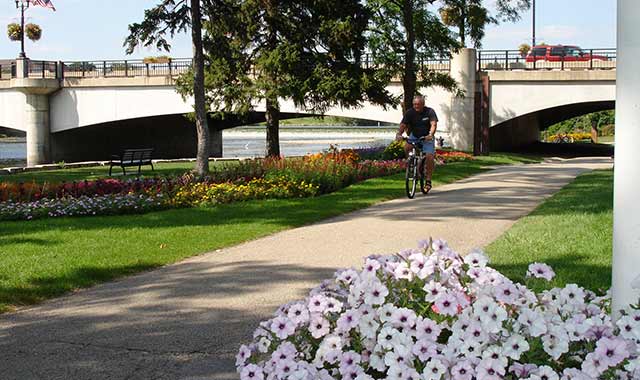
Travel the length of Kane County and pass through nine downtown business districts, all while taking in amazing views of the Fox River. The trail is built mostly along former rail lines, so the riding is easy for most skill levels. Many stretches of the path are paved, especially within downtown business districts.
“Our office is right off the path, and there are a lot of families on the trail,” says Krisilee Murphy, director of marketing for the Elgin Area Convention & Visitors Bureau (CVB). “I also see a lot of experienced bikers along the trail, decked out in all of their gear.”
Along its meandering 40-mile route, the trail provides quiet glimpses of the Fox River and several forest preserves, including Fox River Shores in Carpentersville. The preserve’s mile-long riverfront property is filled with color during spring.
Around Elgin, casual riders enjoy taking photos at several landmarks, such as Pratt’s Castle, Walton Island and the Fox River Trolley Museum. Near East Dundee’s depot, nightly events in summertime attract farmers markets and car enthusiasts. Elgin, too, hosts weekend farmers markets.
Picnic spots dot the trail, although many bikers choose to dine and rest within downtown business districts. In Elgin, the Gail Borden Public Library has public rest stops and bike racks, and the Grand Victoria Casino welcomes bikers with a bike pump, racks and several dining rooms.
Further south, near St. Charles and Geneva, the trail passes public parks and many popular fishing spots. Bike shops right off the trail serve as convenient starting points.
Before hitting the trail in Elgin, pick up a map at the Elgin CVB. If you’re in another community, stop by the local Chamber of Commerce office. Construction, especially around I-90 this year, occasionally causes trail detours.
“It’s best to check with us or the forest preserve district before you head out,” says Murphy. “Usually, the trail detours are along bike-friendly areas.”
Prairie Trail
Route: 26 miles from Kane County border/Algonquin to Wisconsin state line
From the Fox River Trail’s end point in Algonquin, the Prairie Trail leads bikers to the Wisconsin state line and beyond. Along the way, it passes through quiet prairies and farmlands, and four quaint downtown business districts.
Riders can start in Algonquin, where they’ll cross the Fox River on an original railroad bridge. From there, they’ll travel along an abandoned rail line toward downtown Crystal Lake. North of downtown, the trail continues toward McHenry and Richmond, along one of the nation’s longest trails on an active rail corridor.
Because it’s built along a rail line, this trail is relatively easygoing for riders of all skills. North of downtown Crystal Lake, though, the trail climbs several challenging hills within the Sterne’s Woods preserve. About 18 miles of the Prairie Trail, from McHenry to Algonquin, are paved asphalt. Between McHenry and the state line, the trail is covered in crushed limestone.
Along this stretch, riders pass through two quiet forest preserves managed by McHenry County Conservation District, which also maintains the trail. The largest, Glacial Park, encompasses 3,400 acres of wild prairie, savanna and marsh around Nippersink Creek.
At the state line, the North Branch preserve encompasses portions of Nippersink Creek, oak savanna and sedge meadow. Here, a spur runs from the Prairie Trail toward Hebron, across a former rail line that used to stretch from Kenosha, Wis., to Rockford.
Restrooms and water pumps are located at several points along the path, mostly within the nature preserves, and many bike shops located just off the trail also welcome riders. Parking is available within the forest preserves, at the trailhead in Algonquin and within each downtown.
Walkers and runners are welcomed on all sections of the trail, though the northernmost nine miles are also shared by horseback riders and, in winter, snowmobilers.
Illinois Prairie Path
Route: 15 miles from Maywood to Wheaton, with additional spurs to Elgin, Geneva, Batavia and Aurora
The nation’s first rail-to-trail conversion spans some 61 miles, but it also intersects with many other trails around the region, including the Fox River Trail. It does so through spurs connected to Elgin, Geneva, Batavia and Aurora.
Much of the trail is a crushed limestone surface, and because it’s a rail trail, most of the path is easygoing.
Bruce Heidlauf, owner of Mill Race Cyclery in Geneva, enjoys traveling portions of the trail and often leads bike tours along its route. One favorite destination is Fermilab, east of Batavia.
“I’ll often ride the Fox River trail to Batavia, and take the Illinois Prairie spur toward Fermilab,” he says. “Then, I’ll turn north and go up toward Wayne, up to Elgin and then back down to Geneva. That’s about 50 miles round-trip.”
East of Geneva and Batavia, the trail meanders through tree canopies and past open meadows. “When you’re biking, the biggest attraction is along the bike trail,” says Heidlauf. “There’s not much to do and see along the way, so it’s a great getaway. Once you’re in downtown Wheaton, there’s plenty to see.”
Restrooms and water fountains are scattered along the trail, and businesses like Mill Race Cyclery welcome bikers. Parking spots are located within every community along the trail, mostly in public parks and public lots. Parking in downtown Geneva puts you close to the action.
Heidlauf says public safety concerns aren’t an issue on the trail, largely because it’s well trafficked.
“There are some areas you should be careful about at night,” he says. “But if you use some common sense, you’ll be OK.”
Great Western Trail
Route: 17 miles from east Sycamore to St. Charles
Although this converted rail trail passes through Sycamore, Campton Hills and St. Charles, much of it also passes quiet farmland and meadow near Illinois Route 64.
Start your journey at Sycamore Community Park and ride to the trailhead near Rt. 64 and Old State Road. The trail ends just west of Randall Road at LeRoy Oakes Forest Preserve, where it connects to routes that lead toward downtown and the Fox River Trail.
From start to finish, the gradation of this crushed limestone trail isn’t more than 2 percent, making for an easy ride, says Terry Hannan, superintendent for the DeKalb County Forest Preserve District, which maintains a portion of the trail. The remainder is maintained by the Forest Preserve District of Kane County.
The trail has no restrooms or water stops, but many nearby businesses are biker-friendly.
“As you travel the trail, you’ll see native prairie, some forested spots, and many wide-open spaces and farm fields,” says Hannan. “Sycamore has excellent restaurants, coffee shops and nice restaurants for people using the trail.”
The trail is also popular with hikers and snowmobilers. During warmer months, you’re likely to spy cross-country runners from Sycamore High School or Northern Illinois University. On Sycamore’s south side, the paved DeKalb/Sycamore trail begins its route toward the university, on a path that’s roughly eight miles.
Sugar River Trail
Route: 24 miles from New Glarus, Wis., to Brodhead, Wis.
This converted rail trail in southwest Wisconsin is popular with travelers. Situated among rolling hills, the crushed limestone trail is almost completely flat, and in some areas, quite isolated.
The trail passes through several small communities, each with parking spots and trailheads, but perhaps the best starting point is the trail headquarters in New Glarus, a railroad depot that’s also home to the local Chamber of Commerce. There, at the trail’s northern endpoint, riders find ample all-day parking and a host of services, including restrooms and a convenient taxi service.
“You can call the Chamber, and someone will drive you in your vehicle, with your bike, to a starting point, and then leave your car at a designated spot for you,” says Susie Weiss, chamber director.
The trail is maintained by the Wisconsin Department of Natural Resources, and a state trail pass is required for riders 16 and older. Passes cost $4 per day or $20 for a full season, and can be purchased at the trail headquarters in New Glarus, trail entrances and several local shops.
Portions of the trail near Monticello connect with the Badger State Trail, another limestone rail trail that runs from Madison, Wis., to Freeport, Ill. A segment of the Sugar River Trail is also designated as the Ice Age National Scenic Trail, a 1,000-mile recreation path that winds through Wisconsin.
Some portions of the trail are fairly remote, so be sure to pack emergency provisions.
“If you do run into trouble, occasionally the Department of Natural Resources or the Chamber can offer rescue services,” says Weiss. “Always bring a portable hand pump and some tools, just in case.”


